Dublin Core
Title
Description
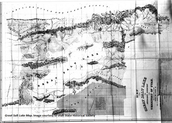
Captain Howard Stansbury journeys around the Great Salt Lake.
In 1849, officials of the US Army Corps of Topographical Engineers sent Captain Howard Stansbury on a two-year expedition to the Great Basin with a long list of orders.
At the top of the Army’s list was a comprehensive survey of the Great Salt Lake, the Jordan River, and Utah Lake. But that was only one small piece of what Stansbury’s superiors hoped he would accomplish. They also ordered the Captain to assess the Great Salt Lake’s navigability, study the local Indian tribes and recently-settled Mormons, locate a site for a military post in the region, and find a wagon road between Fort Hall on the Oregon Trail and the Great Salt Lake Valley. All daunting tasks for a mere mortal.
Perhaps Stansbury’s greatest accomplishment from that ambitious list was his four-week circumnavigation by land of the Great Salt Lake. Taking five men and sixteen mules, the Captain set out around the lake, occasionally passing, as he put it “thousands of acres” of land covered with wild ducks and geese. The lake, with its barren rocky islands, intrigued the men of the party. It had a rough-hewn beauty about it, but Stansbury was also quick to compare its desolate setting to the “stillness of the grave.” He wrote, “I was surprised to find … although so near a body of the saltiest water, none of that feeling of invigorating freshness which is always experienced when in the vicinity of the ocean.” Stansbury continued, “The bleak and naked shores, without a single tree to relieve the eye, presented a scene so different from what I pictured in my imagination of the beauties of this far-famed spot, that my disappointment was extreme.”
Stansbury’s personal expectations of the Great Salt Lake may have been disappointed, but his survey of the area proved to be a major scientific success and his most enduring professional achievement.
Creator
Brandon Johnson for Utah Humanities © 2014
Source
Image: Great Salt Lake. Map of the Great Salt Lake and adjacent country of the Territory of Utah by Capt. Howard Stansbury. Map published in 1852. Image courtesy of Utah State Historical Society.
_______________
See Howard Stansbury’s 1852 expedition report, Exploration and survey of the valley of the Great Salt Lake of Utah, including a reconnaissance of a new route through the Rocky Mountains, available online at https://archive.org/details/explorationsurve00stan; for local newspaper traces of the Stansbury Expedition, see the August 10 and August 31, 1850, editions of the Deseret News; also see David L. Bigler, Forgotten Kingdom: The Mormon Theocracy in the American West, 1847-1896 (Logan: Utah State University Press, 1998), pp 53-54; and Michael S. Durham, Desert Between the Mountains: Mormons, Miners, Padres, Mountain Men, and the Opening of the Great Basin, 1772-1869 (New York: Henry Holt and Company, 1997), pp 231-233.
Publisher
The Beehive Archive is a production of Utah Humanities. Find sources and the whole collection of past episodes at www.utahhumanities.org
Date
2014-11-14

