Dublin Core
Title
Description
Utah’s position as a social and cultural crossroads of the west began well before European settlement. Native trading and war parties gave way to Spanish exploration throughout the territory along the Old Spanish Trail.
Utah’s always been a cultural and social crossroads. Before a single European explorer, trapper, or trader set foot in the Great Basin or on the Colorado Plateau, native trading and war parties could be found ranging far and wide across the region’s deserts and mountains. Then Spanish traders arrived in the southwest and began pushing north from New Mexico, flouting a policy set down by the colonial government in Santa Fe that prohibited commerce with the Utes. Fears about the possibility of California falling into the hands of the Russians and British who threatened to move down the Pacific Coast from Alaska and Oregon, however, helped reverse Spanish policy and soon New Mexico’s governors were sending explorers north to find a path from Santa Fe to California.
The first of the pathfinders was Juan Rivera, whose small party of Spaniards in 1765 followed the La Plata and Dolores Rivers through present-day Colorado, before crossing into what is now Utah near Monticello. They then traveled northward into Spanish Valley around modern-day Moab and finally looped to the west and dropped back into New Mexico. A subsequent party of explorers under Francisco Dominguez and Silvestre Velez de Escalante made it as far north as Utah Lake in present-day Utah County before turning back to Santa Fe.
It wasn’t until decades later that Mexican and American trappers and traders operating out of New Mexico, began to give formal shape to the Old Spanish Trail, using the early expeditionary routes as a framework. Setting out from Abuquiu, just north of Santa Fe, trader Antonio Armijo set out across the Four Corners region, crossed the Colorado River, and pushed past modern-day Kanab, before dropping down the Virgin River and trooping across the Mojave Desert into San Bernardino. The next year, two Americans, William Wolfskill and George Yount created a northern branch of the trail when they followed the path blazed by the Rivera party into today’s Grand County, turned northwest toward what’s now Green River, and after fording the Green, passed near present-day Castle Dale before turning into Salina Canyon. Coming out of the canyon, they trudged up the Sevier River, crossed the Markagunt Plateau near Parowan, and then cut across the Mojave into California.
Creator
Source
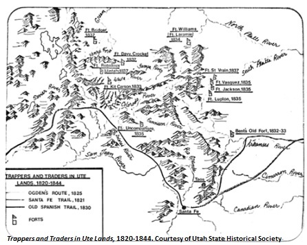
Image: Trappers and Traders in Ute Lands, 1820-1844. Map depicting the forts in Wyoming, Colorado, and Utah; also shows the trails taken by Ogden, the Santa Fe Trail, and the Old Spanish Trail. This map demonstrates Utah as a cultural crossroads of the west. Courtesy of Utah State Historical Society.
_______________
See Richard D. Poll, ed,, Utah’s History (Logan, Utah: Utah State University Press, 1989), 35-51; Peter H. DeLafosse, ed., Trailing the Pioneers: A Guide to Utah’s Emigrant Trails, 1829-1869 (Logan, Utah: Utah State University Press and Utah Crossroads, Oregon-California Trails Association, 1994), 9-32; Ted. J. Warner, ed., The Dominguez-Escalante Journal (Salt Lake City: University of Utah Press, 1995); and Thomas G. Alexander, Utah: The Right Place 2d ed. (Salt Lake City: Gibbs Smith, 2003), 52-57 and 66-67.

